Heavy snow on Maui. Historic floods on Kauai. Hawaii weather is getting weird
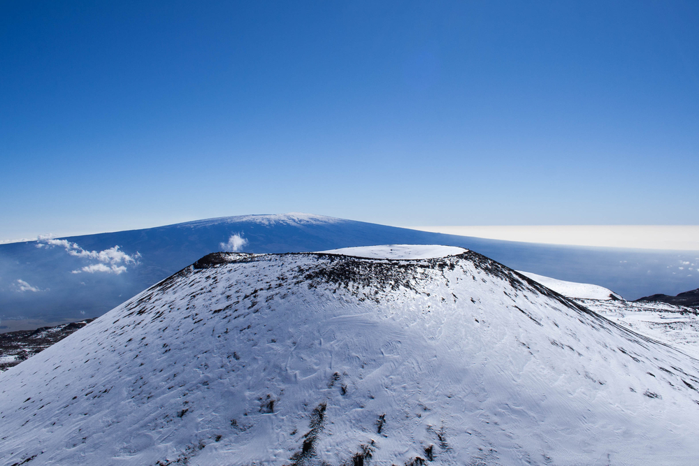
In early February, more than a foot of snow blanketed Polipoli Spring State Recreation Park on Maui — elevation 6,200 feet. Though records are spotty, it’s believed to be the lowest elevation snowfall in modern Hawaii.
In other words, it was a pretty weird weather event. And that makes it part of a trend.
From historic rains and flooding on Kauai last April to the first tropical storm to make landfall on Maui in September, Hawaii has seen some strange — and record-breaking — weather in recent years.
And an emerging area of science is seeking to better predict these weird events, which experts say are likely to happen more often as global warming’s effects become more pronounced.
“This is a very new topic of research and it appears that these sorts of odd weather patterns — whether it’s in Hawaii or Siberia or Minnesota or anywhere around the Northern Hemisphere — can occur more often,” said Jennifer Francis, senior scientist at the Woods Hole Research Center.
A postmortem of the winter storm that dropped potentially record snow in the islands and left behind a path of damage offers insight into how so-called weird weather events could be linked to climate change.
It all started with the polar vortex that hit the mainland in late January, killing several people. The blast of Arctic air brought frigid, record-low temperatures and dumped heavy snow across a wide swath of the country.
A “spectacular event” happened when the polar vortex split into three parts.
Kevin Hamilton, University of Hawaii atmospheric science researcher, stresses that any analysis of the winter storm is speculative, but what he can say is that the system was unique.
“This was happening in the middle of a very disturbed period” for the Northern Hemisphere, Hamilton said.
“The normal, nicely formed westerly vortex, where the wind is blowing around the pole from west to east, got very disturbed, and that vortex actually split into three pieces — again, almost unprecedented,” Hamilton said. “Once that happened, people were suspecting we might see very disturbed weather over the next few weeks, which we have gotten to see.”
Atmospheric scientist Jennifer Francis studies the relationship between a rapidly warming Arctic and weather patterns in mid-latitudes. She said she also suspects the polar vortex did have some kind of influence on Hawaii because odd weather that happens in one place is usually connected to odd weather in other places.
It all has to do with the interaction between the polar vortex and the jet streams.
The jet streams, which are about 5 to 7 miles in the atmosphere, are bands of strong winds that blow from west to east. They essentially control and create the weather, especially in the winter time, she said.
The polar vortex, meanwhile, occurs much higher in the atmosphere, about 30 miles up. It’s a pool of cold air that sits over the Arctic. Unlike the jet stream that exists all year long, the polar vortex only exists in the winter.
Francis said the polar vortex usually moves in a quick and circular fashion right over the Arctic. But this year, something caused it to become less circular — almost like a dumbbell shape — allowing it to split apart.
“When this happens, which is exactly what happened last month, we had one of these pools of cold air settle down over North America and it sort of reinforced that really cold air that broke a lot of records, especially in the upper Midwest,” Francis said. “But in addition to causing these cold outbreaks and severe cold temperatures, it also tends to reinforce these big waves in the jet streams down lower in the atmosphere.”
This was probably what led to the strong storm system in Hawaii, Francis said.
“You can think of it as an eddy in the jet stream that separated itself. It was like the jet stream took a sharp dip southward, over the Pacific Ocean, and less behind this swirling area of cold area with strong winds wrapped around it in the upper levels.”
Hamilton said the role of stratospheric vortex disturbances in development in the lower atmosphere is an “interesting” subject that’s gained traction recently — and could hopefully lead to improved long-range weather forecasting.
“People are more and more convinced that the disturbed vortex, in the stratosphere, high in the atmosphere, leads to more south meander, more wobbly jet streams, and hence these cold spells in mid-latitudes which were so strong,” he said. “One of them was so strong this year we kind of got clobbered in Hawaii.”
Also with this low pressure system: much cooler temperatures statewide, with temperatures dipping to the 50s in some areas.
“There was an extended period where we had northerly winds, so anytime you have northerly winds, it brings cooler, drier air over the islands from the north,” said Tom Birchard, meteorologist for the National Weather Service.
According to NWS, the average temperature for February was 0.7 degrees below the long-term mean. While it felt “freezing” by Hawaii standards, this was because average February temperatures over previous years were actually slightly above, or warmer, than the long-term mean.
Hamilton said Hawaii is actually experiencing warmer winters as a result of global warming, but this year’s cooler February was what was considered a “natural variance.”
“If you ask me what’s going to happen 20 years from now, you’re going to find almost all the winters are going to be warm compared to what they were say in the late 20th century just because the warming trend eventually will dominate over the year to year natural variations,” he said.
Birchard, meanwhile, said he sees these types of winter storms on a fairly common basis in the Pacific.
“The strength or the vigor of the mid-level low was unusually strong, but I wouldn’t necessarily say that’s something we’ve never seen before. It was just something that was unusually strong and unusually cold,” Birchard said.
Although it’s too soon to say whether climate change had a direct effect on this storm or the polar vortex for that matter, Jennifer Francis said several studies have already found that melting glaciers in the Arctic, particularly in an area north of western Russia, have been leading to strange weather patterns.
“We know that sea ice is disappearing in the Arctic because of climate change, there’s no other explanation,” she said. “This particular area, which is one of the areas where sea ice has been disappearing the fastest, appears to be special in that it has this very influential connection to the polar vortex and is possibly causing these splits to happen more often, which can then lead to a lot of bizarre weather all around the Northern Hemisphere.”
Although the link between bizarre weather systems and climate change is still debatable, Francis said emerging research shows there are a lot of ways it’s affecting this pattern.
“Some of them are extremely well understood and clear cut and others are emerging, like this particular connection.”