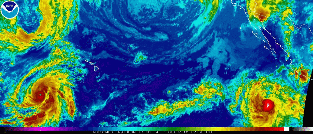
Update: Hurricane Walaka has Grown to Category 5
At 11:00 p.m., the center of Hurricane Walaka was located about 955 miles west-southwest of Honolulu or about 210 miles south of Johnston Island.
Walaka is moving toward the north-northwest near 8 mph. A turn toward the north is expected later tonight with an increase in forward speed expected Tuesday through Wednesday.
On the forecast track, the center of Walaka is expected to pass just to the west of Johnston Island on Tuesday.
Maximum sustained winds are near 160 mph with higher gusts. Walaka is a category 5 hurricane on the Saffir-Simpson Hurricane Wind Scale. Little change in intensity is expected through Tuesday, with a weakening trend expected to begin late Tuesday night or early Wednesday.
Hurricane-force winds extend outward up to 45 miles from the center and tropical-storm-force winds extend outward up to 185 miles.
Watches and Warnings
A Hurricane Warning is in effect for Johnston Atoll.
A Hurricane Warning means that hurricane conditions are expected in the warning area. A warning is typically issued 36 hours before the anticipated first occurrence of tropical-storm force winds, conditions that make outside preparations difficult or dangerous.
A Hurricane Watch is in effect for Papahanaumokuakea Marine National Monument from Nihoa to French Frigate Shoals to Maro Reef.
A Hurricane Watch means that hurricane conditions are possible within the watch area within 48 hours.

Summary information:
- LOCATION…13.7N 170.0W
ABOUT 210 MI…340 KM S OF JOHNSTON ISLAND
ABOUT 955 MI…1535 KM WSW OF HONOLULU HAWAII - MAXIMUM SUSTAINED WINDS…160 MPH…260 KM/H
- PRESENT MOVEMENT…NNW OR 330 DEGREES AT 8 MPH…13 KM/H
- MINIMUM CENTRAL PRESSURE…921 MB…27.20 INCHES
Central Pacific Hurricane Center Discussion
Walaka continues to display a warm well defined eye surrounded by a ring of -65 to -85C cloud tops. The presentation in geostationary satellite imagery has changed very little since the previous advisory, with perhaps a bit of an improvement in organization over the past hour. The most recent morphed microwave imagery from UW-CIMSS indicates that Walaka may be going through an eyewall replacement cycle, so the down trend seen in the overall satellite presentation that began late Monday afternoon, may only be temporary. The latest intensity estimates from PHFO, SAB, JTWC all came in at 6.5 (127 knots) while ADT was 6.8 (135 knots). Given several satellite images Monday afternoon around 02/00Z showing T numbers of 7.0 (140 knots), and the likelihood that an eyewall replacement cycle is ongoing, the initial intensity was held at 140 knots for this advisory. The initial motion was set at 330/07 knots.
A deep north Pacific upper level low in the vicinity of 30N 170W will draw Walaka northward over the next several days, before another sharp upper trough shifting across the north Pacific picks the tropical cyclone up and shifts it off to the northeast. Overall the guidance envelope remains fairly tightly clustered through the forecast period. The official forecast remains very close to that of the previous advisory and remains closely aligned with the GFEX, TVCN, HCCA consensus guidance.
The environment surrounding Walaka remains conducive for additional intensification during the next 24 to 36 hours. The tropical cyclone will remain within a deep moist airmass, with low vertical wind shear, and sea surface temperatures between 84 to 86 Fahrenheit. Eyewall replacement cycles will likely lead to fluctuation in intensity through this time frame, so the intensity forecast shows little intensity change through 36 hours. Beyond 36 hours, vertical wind shear will increase, drier mid-level air will begin to get wrapped into the cyclone, while sea surface temperatures become marginal and even unfavorable. As a result, Walaka should begin to weaken on Wednesday, with rapid weakening then expected through the end of the forecast period. The official forecast was not changed much from the previous advisory, and remains above all guidance through 36 hours and then trends closer to a blend of the statistical and dynamical models thereafter.
The forecast track will take Walaka near Johnston Island on Tuesday, so the Hurricane Warning remains in effect for this location. The forecast track also takes the hurricane across the Papahanaumokuakea Marine National Monument between French Frigate Shoals and Laysan Island late Wednesday. Thus, a Hurricane Watch remains in effect for the region from Nihoa to Maro Reef.