Typhoon Mangkhut: Philippines hit by super typhoon
Super Typhoon Mangkhut has reached the Philippines, blasting the northern coast with strong winds and heavy rain.
Forecasters say the typhoon, with winds of 205km/h (130 mph) and gusts of up to 255 km/h, is the strongest storm of 2018 so far.
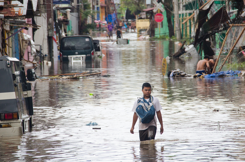
More than four million people are directly in the path of the storm – and thousands have been evacuated.
Officials have warned of storm surges of up to 6m (20ft) and “very heavy damage” to vulnerable structures.
They have raised alert levels to the second-highest – signal four – in Cagayan, northern Isabela, Apayao and Abra provinces
The deadliest storm on record in the Philippines is Super Typhoon Haiyan, which also sparked category four alerts.
Typhoon Haiyan killed more than 7,000 people and affected millions in 2013.
Where is Typhoon Mangkhut hitting?
It made landfall at Baggao, in the north-east of the country, at about 01:40 local time on Saturday (17:40 GMT on Friday)
Officials have said the storm, which is 900km in diameter, could be “very destructive” even if it weakens after landfall.
The typhoon is then forecast to keep heading west, passing through Hong Kong on Sunday afternoon.
Weather experts say it may be the strongest tropical storm to hit the territory in decades.
Hong Kong authorities have warned urged residents to stay indoors when the storm approaches.
How has the Philippines prepared for the storm?
Storm warnings have been issued in dozens of provinces, and sea and air travel has been restricted.
Flights have been cancelled, schools shut and the army is on standby.
The authorities have also warned that heavy rains could trigger landslides and flash floods.
More than 9,000 people have been evacuated to shelters.
“We are really frightened,” Delaila Pasion, who had fled her home, told AFP news agency. “They say it is so strong, we were too scared to remain.”
“During previous monsoon rains, half of our house was destroyed so I wanted to take my grandchildren to safety,” she told journalists.
The Philippines is routinely hit during the typhoon season.
The storm – known locally as Ompong – has already struck the Northern Mariana Islands and Guam.
China has also been making preparations.
In China, authorities have raised storm alerts to “yellow”, which is the second level on its four-tier warning system. It is predicted to hit China late on Sunday or early Monday.
High-speed rail services have been cancelled in parts of southern China, local media report.
Is global warming to blame?
The relationship between climate change and tropical storms is a complex one.
Typhoons and hurricanes form when air, heated by warm sea water, rises quickly.
As the air cools down again it is pushed aside by more warm air rising below it – causing strong winds and whipping up waves.![]()
So as the temperature of ocean water goes up, we might expect the intensity of hurricanes to increase in future.
A hotter atmosphere can also hold more water, so this should allow hurricanes to dump more water on affected areas.
But there are so many factors that contribute to these events, it has been difficult to tease out clear trends from the data.
Calm before the storm
Howard Johnson, BBC News, Arparri, Luzon
Residents of this small, low-rise town say they’ve been through this before, they’ve seen other storms.
Farmers are working around the clock to harvest their rice paddies. They say the rice is still not ripe, but want to salvage what they can before this storm potentially devastates their fields.
Authorities have told people to move on. Some cars are leaving the area, bedding on the roof – but some people say they want to stay inside their homes to prevent thieves entering.
People seem to be very relaxed with the idea that a super typhoon is coming their way.